To Grid Or Not To Grid


To Grid Or Not To Grid - That is the Question


An interesting article by city planner Pete Pointer, FAICP, ALA, ITE on the grid system in city development in the Journal of City Development.


journalofcitydevelopment.com


___________________

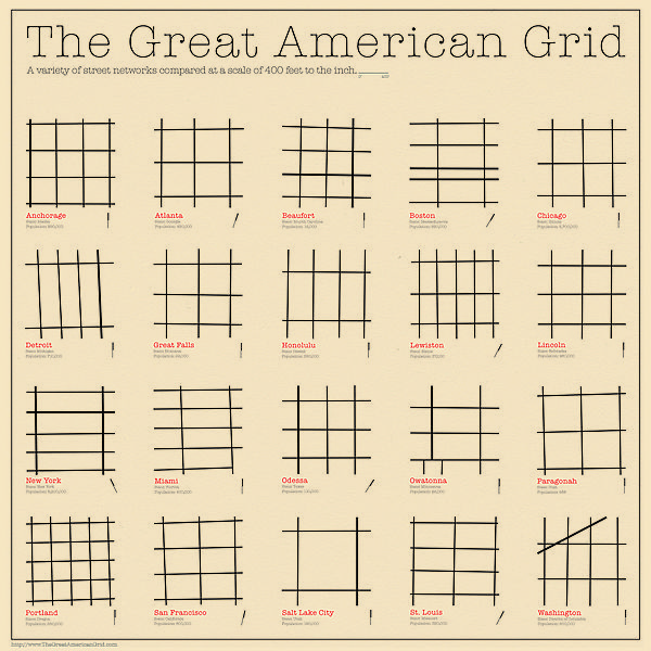
Having grown up in the midwest I am a grid guy. There is nothing wrong with some curvilinear streets and cul de sacs to give our urban landscape a little diversity. But they should connect back into a logical grid and not just meander aimlessly. And good planning demands that cities and counties examine their grids, and prepare a plan that proposes to connect and realign roads to complete a logical grid.


More on Grids Below
  1. Grid plan - Wikipedia, the free encyclopedia

    en.wikipedia.org/wiki/Grid_plan
    A simple grid plan road map (Windermere, Florida). ... Perhaps the most well-knowngrid system is that spread through the colonies of the Roman Empire.
  2. Milton Keynes grid road system - Wikipedia, the free encyclopedia

    en.wikipedia.org/wiki/Milton_Keynes_grid_road_system
    The Milton Keynes grid road system is a network of national speed limit, fully landscaped routes that form the top layer of the street hierarchy for both for private ...
  3. Grid system of roads to cover length and breadth of city - The Hindu

    www.thehindu.com › Cities › Chennai
    Jun 9, 2012 – Residents of localities in all the fifteen zones not adequately covered under the grid system of roads will soon see significant improvements to ...
  4. With Council's approval, work on grid system of roads to begin ...

    www.thehindu.com › Cities › Chennai
    Apr 19, 2012 – Initiative will cover 175 km of roads in all eight zones of newly added areas.
  5. Human Transit: the power and pleasure of grids

    www.humantransit.org/.../the-power-and-pleasure-of-grids.ht...
    Feb 23, 2010 – In an ideal grid system, everyone is within walking distance of one .... in the case of well-funded, completed networks like paved roads, just ...
  6. Images for grid system of roads

      - Report images
    •  
    •  
    •  
    •  
  7. Street Grid system in cities around the country - Straight Dope ...

    boards.straightdope.com/sdmb/showthread.php?t=528896
    35 posts - 29 authors - Aug 20, 2009
    The grid system works all the way down to Homestead where some of .... because there are also a numbered Drives, Roads & Places, which I ...
  8. Grid system of road networks.

    www3.sympatico.ca/bobmcmu/grid_system.htm
    A description of how developers negate essential community sidewalks with arguments to make more profit.
  9. Suburban areas to get world class integrated roads - Times Of India

    articles.timesofindia.indiatimes.com › Collections › World Class
    Apr 19, 2012 – CHENNAI: The extended areas of the Chennai Corporation will soon get world class civic amenities as the local body has approved Rs 182 ...
  10. How Grid Systems Promote Urbanism and Winding Streets ...

    streetsblog.net/.../how-grid-systems-promote-urbanism-and-wi...
    Aug 23, 2012 – Connected street systems could be grids or could be the less rationally.... has the greatest mish-mash of a road system that I have ever seen.

Connecting The Grid


The effort above should be made by the Sarasota Manatee MPO with the two County and municipal goverments.  The plans should be incorporated into Land Use and Transportation Plans

The maps show planned connections to improve the grid in eastern Will County south of Chicago. As the area urbanizes the "Kinks" in the grid should be "worked out", with logical connections made.

It is remarkable how little planning effort is made to improve the base road grid of a community.  A little thinking and planning can make the grid much better.  There will always be some misalignment of roads and some roads that do not connect.  A good plan should make sure that logical connections are planned and that they are developed before or when new development occurs.

Part of the reason that we do little of this is that most of us focus on our community only, with minimal thought about connections to other communities.  Or we may come up with a good connection but it fails at the next town.

Transportation planning is often focused on major road development, or on programming of funds for improvements. There is seldom anyone looking at the overall grid of a large area and coming up with logical plans for improvements over time.

The road realignment plan should be integrated with the land use plan.  And realignments at County and State lines should have special interest since their is no single entity paying much attention to these important connections. The map below shows road realignments with the land use plan for eastern Will County with the proposed third airport for Chicago. 


The map below shows the plan for connecting local roads between Illinois and Indiana south of Chicago.


Of course one of the concerns is that it will take many years for this area to develop. Will the local planners consider this when they approve a land use decision?  Often they will not and we are then left with irritating dog legs in our grid. 

Better To Create An Additional Freeway Then To Do This


It is much better to build an additional freeway further away then to create this mess.  All over America we are widening the pavement on our high capacity roads.  Freeways that once had landscaped center and side medians now become a concrete jungle.

Future freeway corridors should be wide, with permanent safe attractive landscaped medians. Not This!
The I-10 freeway which runs from Florida to South California is the widest freeway in the USA in the section running from Katy, TX (a Houston suburb) to downtown Houston, TX, a distance of around 22 miles.
The freeway averages 22 lanes, and in some sections (Intersection of BW8 loop with I-10) it has 26 lanes total including 6 feeder and 4 HOV lanes. In spite of this, during morning commute hours it takes an hour and a half to get from Katy, TX to downtown Houston.

Green Spine

The Green Spine is a proposal for a new transportation and environmental corridor. The spine would connect the major natural areas of the State and provide a transportation corridor for the future.

The corridor would be east of I-75. The corridor would be 1,320 feet wide with 400 feet for a future high tech interstate highway. The wide right of way would ensure that the interstate could have wide safe shoulders and a green center median. This wide right of way would ensure that the road would always be able to have natural landscaping on both sides of the road and in the median.

The Green Spine would also preserve 100 feet width for high speed rail, and 200 feet for utility corridors - gas, electric, oil, cable.

The balance of the right of way would be natural environment.

Summary - right of way

Interstate400
Rail100
Utilities200
Nature620
Total1,320


Interstate Highways in major urban areas are widened until they are ugly and unsafe.  And it appears that the United States will continue to grow in population and we will continue to
widen our interstates.  

What once was an attractive safe road with wide natural landscapes on both the side and center medians become the photos above and below.

Manatee County Future Land Use Plan

Sustainable Development


Sarasota, Florida is a great place to start or expand your business.  And our eight Sister Cities are also ready to help you expand your business into their countries. 


Sustainable "Green" Economic Development combines environmental improvement and traditional economic development into one discipline. Traditional economic development can be employed to increase employment while improving our environment. Economic Development and  “Green” Development can be synergistic, improving our overall quality of life. 

               KEEP    

  11111Keep our businesses and jobs
  11111Expand the businesses we have
  11111Enhance our community to attract new businesses
 111111Protect and continuously improve the environment

For assistance in locating or expanding your business in Sarasota or in one of our Sister Cities contact:

Craig Hullinger
Vice President Economic Development
309 634 5557
sarasotasistercities@gmail.com


MORE INFO AT:


pinterest.com/sarasotasister


                       ECONOMIC DEVELOPMENT LINKS

SarasotaFL.gov

sarasotafl.gov/government/city-manager/office-of-economic-development

Honore Park - Proposed


A small park on Honore south of Ward Lake would be an outstanding addition to our region. The park would provide access for neighbors to walk to and enjoy the lake. The Lake and adjacent land is owned by the City of Bradenton and could easily be leased by the County. The fence that keeps people away from the Lake should be taken down.

The successful Jiggs Landing Park on the other side of the Lake is operated by the County. It is a very nice facility but is a long and dangerous walk or bike ride from neighborhoods near Whitfield and Honore on Rt 70. A small park on Honore is a much better solution.


The map above and below is from the Manatee County GIS. It shows that all the property between the  Lake south to Honore is owned by Bradenton.  A simple lease agreement between the County and the City would enable the park.

Very little  money is required. The fence can be taken down and people will have access to the lake. Eventually a  small parking lot with access lining up with Magnolia Ridge would improve access, and a grass mowed path from Honore and the Lake would be desirable.


Click to Read More
http://honorepark.blogspot.com/


View on Google Maps


Manatee County GIS